How do you assess 26 kilometers of highway corridor for expansion when traditional surveys would take 6 weeks and expose crews to dangerous terrain?
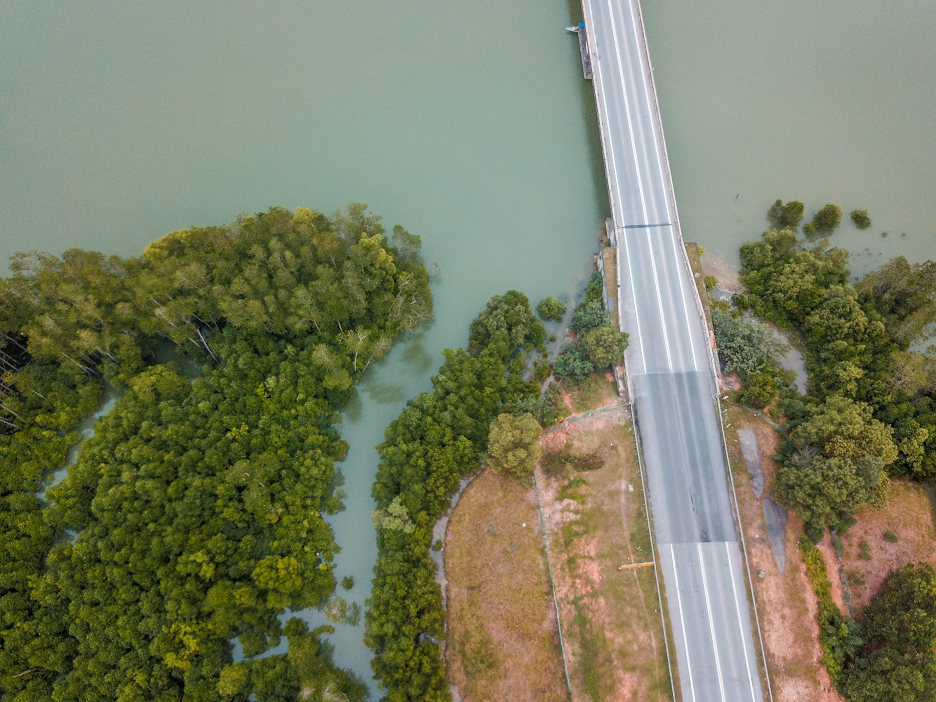
Infrastructure projects demand detailed site assessments before design and planning phases can proceed. Traditional ground surveys and helicopter inspections are costly, time-consuming, and often logistically challenging. In Johor, Malaysia, an initial pre-survey was conducted for a proposed highway expansion project along a 26km stretch of existing single-lane highway, planned for upgrade to a two-lane carriageway to improve traffic flow and accommodate future growth.
This case study demonstrates how aerial drone mapping delivered fast, cost-effective, and comprehensive visual inspection to support the pre-study proposal, helping engineers and stakeholders understand existing conditions and potential challenges along the entire corridor.
The Infrastructure Challenge: 26km of Complex Terrain
Project Scope and Requirements
Project Overview:
- Location: Johor, Malaysia
- Corridor Length: 26 kilometers of existing single-lane highway
- Planned Upgrade: Complete expansion to two-lane carriageway
- Mixed Environment: Flatlands, plantations, rivers, swamplands, and hilly terrain
- Critical Timeline: Rapid assessment needed for feasibility study and funding approval
Traditional Survey Limitations
The diverse terrain presented significant challenges for conventional assessment methods:
Accessibility Constraints:
- Swampland sections posing safety risks for ground crews
- Steep hillside gradients requiring specialized access equipment
- Multiple river crossings necessitating boat transport and specialized crews
- Dense plantation areas with limited vehicle access
Time and Resource Requirements:
- 4-6 week duration for comprehensive ground assessment
- 10-15 personnel required across multiple survey teams
- Extensive logistics for equipment transport and crew coordination
- High safety risks in environmentally challenging sections
Engineering consultants needed a comprehensive, rapid, and cost-effective method to assess the full corridor and provide actionable data for design planning.
Strategic Drone Mapping Implementation
Comprehensive Corridor Assessment Program
The drone survey methodology was designed to capture complete visual and spatial data across the entire 26km corridor with strategic buffer zones to assess expansion feasibility.
Survey Objectives:
- Provide high-resolution visual documentation of existing highway alignment and surrounding land use
- Identify topographical features and constraints influencing design decisions
- Map natural and man-made obstacles including rivers, bridges, drainage systems, and structures
- Assess environmental sensitivity zones requiring special mitigation measures
- Document access points and utility corridors for construction planning
Technical Implementation:
- Segmented flight missions covering the entire 26km stretch with continuous coverage
- Optimized flight paths with high forward and side overlap for complete data capture
- Strategic altitude settings balancing detail resolution with efficient coverage
- Buffer zone inclusion capturing adjacent land features relevant to expansion planning
Advanced Data Processing and Deliverables
Professional drone photogrammetry software processed captured imagery to generate comprehensive mapping products:
Georeferenced Orthomosaics: Complete visual coverage with geographic accuracy enabling precise measurement and infrastructure mapping
Digital Surface Models (DSMs): Detailed elevation data supporting cut-and-fill analysis and gradient assessment
3D Terrain Models: Interactive visualization tools for stakeholder communication and design optimization
Critical Engineering Insights and Actionable Data
1. Comprehensive Existing Conditions Documentation
Drone mapping provided continuous, seamless visual record of the entire 26km corridor, enabling engineers to understand the complete highway-landscape interaction. Unlike selective ground inspections, this aerial perspective revealed the integrated relationship between highway alignment, plantations, rivers, and hillside sections.
Infrastructure Assessment Results:
- Detailed inventory of existing culverts, bridges, and drainage structures with GPS-accurate locations
- Condition evaluation of roadside infrastructure requiring upgrade or replacement
- Access point identification for construction logistics and utility management
2. Critical Terrain Challenge Identification
The mixed terrain assessment revealed several construction challenges requiring specific engineering solutions:
Swamplands and Flood-Prone Areas:
- Distinct surface patterns in orthomosaics identified areas requiring geotechnical investigation
- Seasonal flooding risk zones mapped through vegetation and soil moisture indicators
- Foundation design requirements informed by wetland boundary delineation
River Crossing Analysis:
- Multiple waterway intersections with precise width and floodplain measurements
- Bridge design parameters established through span requirement analysis
- Hydraulic impact assessment supporting drainage and flood management planning
Hillside Gradient Assessment:
- Steep slope sections identified requiring cut-and-fill analysis and slope stabilization
- Earthworks volume estimation through DSM elevation data analysis
- Retaining structure requirements mapped for challenging terrain sections
3. Environmental Constraint and Land-Use Mapping
Comprehensive environmental assessment identified sensitivity zones and regulatory requirements critical for project approval and design optimization:
Environmental Sensitivity Analysis:
- Wetland boundaries precisely mapped for environmental impact assessment
- Protected vegetation areas identified requiring mitigation measures
- Water body buffers established for regulatory compliance planning
Land Acquisition Planning:
- Plantation boundaries mapped for compensation and acquisition planning
- Existing land use patterns documented supporting community engagement
- Property impact assessment enabling stakeholder communication and negotiation
4. Infrastructure and Utility Integration Assessment
Visual inspection revealed critical infrastructure elements requiring coordination and potential relocation during construction:
Existing Utility Mapping:
- Power transmission lines with clearance requirements for construction equipment
- Communication infrastructure requiring protection or temporary relocation
- Water and drainage systems needing integration with new highway design
Construction Access Planning:
- Service road connections identified for construction traffic management
- Material staging areas evaluated for accessibility and environmental impact
- Emergency access routes established for construction safety protocols
Transformational Efficiency and Cost Benefits
Accelerated Project Timeline
Drone Mapping Performance:
- Survey completion: 3-4 days including data collection and processing
- Data delivery: High-resolution outputs ready for immediate engineering analysis
- Design integration: Immediate availability for feasibility study development
Traditional Survey Comparison:
- Ground assessment duration: 4-6 weeks with weather delays and access challenges
- Crew coordination time: Extensive logistics for multi-team deployment
- Data compilation delays: Manual measurement consolidation and mapping
Time Savings: 90% reduction in assessment duration enabling accelerated project approval
Substantial Cost Reduction
Financial Performance Analysis:
Traditional Survey Costs:
- Personnel: 10-15 crew members over 4-6 weeks
- Equipment: Specialized survey instruments, vehicles, and access equipment
- Logistics: Transportation, accommodation, and safety equipment
- Total estimated cost: RM150,000-250,000 for comprehensive assessment
Drone Mapping Investment:
- Crew requirements: 2-person team with efficient deployment
- Equipment costs: Drone system and processing software
- Operational efficiency: Minimal logistics and accommodation requirements
- Total project cost: RM45,000-75,000 for equivalent coverage
Net Cost Savings: 60-70% reduction compared to traditional survey methods
Enhanced Safety and Risk Management
Personnel Safety Benefits:
- Eliminated ground crew exposure in swampland and steep terrain sections
- Reduced accident risk from hazardous environment operations
- Weather flexibility with rapid deployment during suitable conditions
Project Risk Reduction:
- Comprehensive coverage ensuring no critical features overlooked
- Repeatable methodology enabling follow-up surveys during different seasons
- Quality assurance through high-resolution data verification
Strategic Integration into Project Development
Engineering Design Support
The drone-generated maps and 3D models provided essential foundation data for feasibility study development:
Baseline Documentation:
- Pre-expansion visual record supporting environmental impact assessment
- Existing infrastructure inventory enabling accurate upgrade cost estimation
- Terrain analysis data supporting optimal alignment refinement
Design Reference Integration:
- Preliminary alignment optimization based on terrain and environmental constraints
- Cut-and-fill volume estimation supporting construction cost analysis
- Drainage design parameters informed by existing water flow patterns
Stakeholder Communication Enhancement
Visual Communication Tools:
- Easy-to-understand mapping products for community engagement and public consultation
- Professional documentation for regulatory agency submissions and approvals
- Interactive 3D models supporting decision-maker presentations and funding applications
Collaborative Planning Benefits:
- Multi-disciplinary coordination between engineers, environmental consultants, and planners
- Evidence-based decision making through comprehensive spatial data
- Risk communication enabling informed project approval and resource allocation
Implementation Framework and Best Practices
Critical Success Factors
-
Comprehensive Corridor Coverage: Buffer zone inclusion beyond highway right-of-way ensures complete constraint identification and design optimization
-
Multi-Purpose Data Collection: Single survey mission generates products supporting multiple project phases from feasibility through detailed design
-
Seasonal Timing Considerations: Strategic survey scheduling during optimal weather conditions maximizes data quality and mission efficiency
Scalability and Replication Methodology
The Johor highway expansion pre-survey demonstrates transferable best practices for large-scale infrastructure projects throughout Malaysia and Southeast Asia:
Standardized Assessment Protocols:
- Rapid deployment procedures for time-sensitive project schedules
- Data quality standards ensuring engineering-grade accuracy and completeness
- Integration workflows supporting seamless transition from assessment to design phases
Technology Integration Benefits:
- GIS compatibility enabling overlay with existing infrastructure and regulatory data
- CAD system integration supporting direct import into engineering design software
- Database development for ongoing asset management and maintenance planning
Long-Term Project Value and Strategic Advantages
Evidence-Based Decision Making
Design Optimization Benefits:
- Alignment refinement based on comprehensive terrain and constraint analysis
- Construction method selection informed by accurate environmental and access data
- Cost estimation accuracy through detailed site condition documentation
Risk Mitigation Planning:
- Environmental compliance assurance through complete sensitivity zone mapping
- Construction safety planning supported by hazard identification and access route optimization
- Community relations management through transparent documentation and visual communication
Ongoing Project Support Capabilities
Monitoring and Quality Assurance:
- Progress tracking methodology for construction phase monitoring
- Change documentation supporting design modifications and claims management
- Environmental compliance monitoring during construction implementation
Transforming Infrastructure Planning with Strategic Drone Mapping
The 26km Johor highway expansion pre-survey demonstrates the transformative potential of aerial drone mapping in large-scale infrastructure planning. By delivering comprehensive, high-resolution assessment data at unprecedented speed and cost-effectiveness, drone technology enabled rapid, evidence-based decision making for complex transportation projects.
Contact Dronify today to learn how professional drone mapping can accelerate your infrastructure planning, reduce assessment costs, and improve design accuracy. Our proven expertise in challenging terrain and complex corridor mapping ensures reliable data collection and analysis when rapid, comprehensive assessment is critical for project success.
Whether you're planning highway expansions, transportation infrastructure, or major development projects, our comprehensive drone mapping services provide the foundation for informed decision-making, optimized design, and successful project delivery.