Workflow
Zero-surprise execution through our proven three-phase methodology. Eliminate project uncertainties while delivering measurable competitive advantages that drive strategic business outcomes.
Three-phase methodology framework
Enterprise-grade methodology delivering predictable outcomes through systematic validation checkpoints and quality gates that protect your project timeline and budget.
Risk-mitigation framework
Enterprise-grade methodology developed through 500+ successful flights eliminates operational risks and ensures predictable outcomes. Every phase includes multiple validation checkpoints and quality gates that protect your project timeline and budget.
Strategic integration design
Seamless workflow compatibility with existing project management systems, CAD environments, and GIS platforms. Our standardized deliverable formats ensure immediate usability within your established operational frameworks.
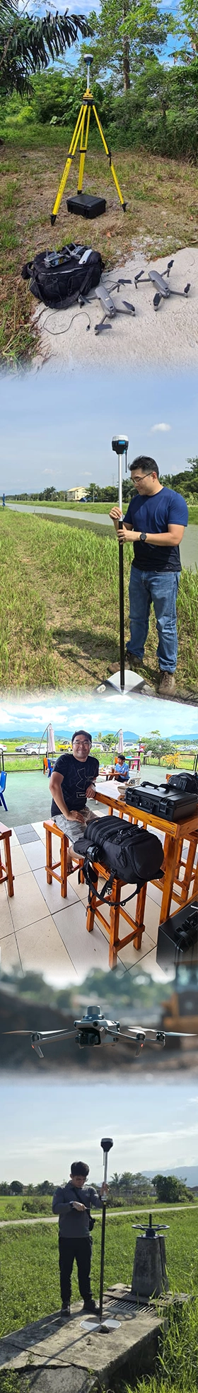
Strategic assessment & precision capture
Comprehensive pre-flight analysis eliminates surprises and optimizes data collection efficiency. RTK/GPS-enabled survey-grade positioning with centimeter-level accuracy standards.
Technical implementation
Project requirement assessment
2–4 hoursComprehensive project scoping eliminates scope creep and ensures precise deliverable specifications. Detailed technical requirements mapping prevents costly revisions and guarantees first-time accuracy.
Pre-flight planning
3–5 hoursRisk-mitigation through strategic flight planning optimizes data collection efficiency while supporting regulatory requirements. Weather contingency planning protects project timelines from operational delays.
Ground control point setup
1–2 hoursSurvey-grade accuracy foundation through precision GCP placement ensures centimeter-level mapping accuracy. Strategic positioning eliminates measurement uncertainties and validates final deliverable precision.
Onsite flight execution
2–6 hoursProfessional data capture execution with real-time quality monitoring ensures comprehensive coverage without gaps. Redundant flight patterns and multi-sensor integration maximize data reliability.
Quality check & coverage validation
1–2 hoursImmediate field validation prevents processing delays and ensures data completeness before site departure. Comprehensive quality gates guarantee deliverable standards without revision cycles.
Business impact summary
Risk mitigation
Eliminates field uncertainties and operational surprises through systematic validation checkpoints
Cost control
Prevents revision cycles and scope creep through comprehensive upfront planning and field validation
Quality assurance
Survey-grade accuracy standards with centimeter-level precision verified before processing begins
Timeline certainty
Weather contingency planning and comprehensive field validation ensure predictable project delivery
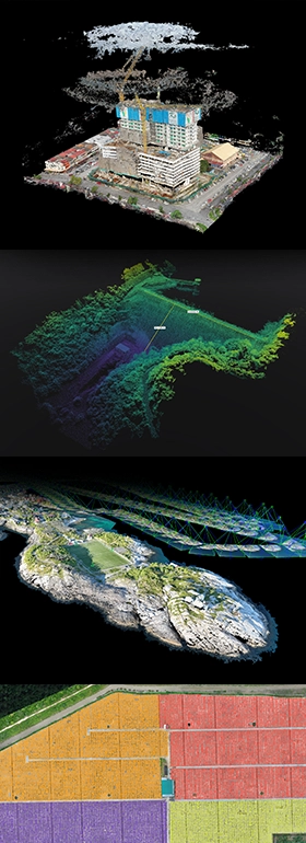
Advanced processing & quality validation
Professional photogrammetry processing using industry-leading algorithms transforms aerial imagery into survey-grade deliverables. Advanced processing pipeline generates precision orthomosaics, full-color point clouds, digital surface models, and comprehensive analysis products with sub-centimeter accuracy validation.
Processing pipeline
Advanced photogrammetry processing
- Professional Structure-from-Motion algorithms with multi-view stereo reconstruction
- Automated point cloud classification (ground, vegetation, buildings, infrastructure)
- rayCloud verification environment for visual accuracy assessment
- Ground Control Point integration for sub-centimeter precision (1–2 pixel GSD X,Y / 1–3 pixels Z)
Quality control & validation
- Comprehensive quality reports with calibration details and accuracy metrics
- Statistical accuracy assessment with Ground Control Point validation
- Real-time processing monitoring with quality indicators
- Industry-standard output validation for CAD/GIS compatibility
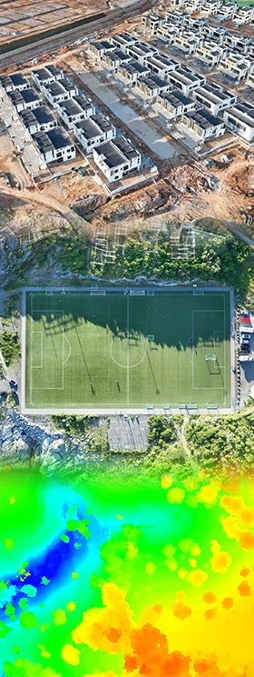
Strategic delivery & integration support
Comprehensive deliverable portfolio featuring precision mapping products in industry-standard formats. Multi-format outputs (orthomosaics, 3D models, point clouds, terrain models) and executive reporting enable immediate integration into existing workflows.
Integration support
Comprehensive deliverable package
- Orthomosaics (GeoTiff .tif, Google Earth .kml) with uniform scale correction
- Full-color point clouds (.las, .laz, .ply, .xyz) with automated classification
- Digital Surface Models (GeoTiff .tif, .xyz, .las, .laz) and Digital Terrain Models
- 3D textured mesh models (.ply, .fbx, .dxf, .obj, .pdf) with level-of-detail options
Specialized analysis products
- Contour maps with customizable intervals (.shp, .dxf, .pdf formats)
- Thermal mapping and index maps (GeoTiff .tif, .shp formats) for specialized analysis
- Volumetric calculations and change detection reports
- CAD/GIS integration support
Methodology assurance
*Standard delivery for projects up to 100 hectares. Larger projects may require additional time. Survey-grade accuracy available with Advanced packages using RTK/GPS and Ground Control Points.