Project Portfolio

Transforming enterprise operations through precision drone mapping. High-stakes projects delivering measurable ROI, accelerated timelines, and competitive advantages for Malaysia's leading organizations.

20+ Projects
RM 2.5M+ Cost Savings Generated
12,400ha Total Area Mapped
1441km Distance Covered

Success Stories

In-depth case studies revealing strategic methodology, advanced capabilities, and quantified business transformation achieved for Malaysia's leading organizations. See how precision drone mapping delivers competitive advantages across critical industries.

Highway Expansion Survey

Client Type Government Infrastructure
Project Duration 2 weeks (vs 12 weeks traditional)
Area Covered 260 hectares
Cost Savings RM 200,000+

Strategic Challenge

Critical highway expansion requiring comprehensive survey across 260 hectares with tight project deadlines and budget constraints. Traditional methods would consume 12 weeks minimum with significant safety risks, budget overruns, and traffic disruption impacting public operations.

Strategic Solution

Deployed aerial drone along with survey-grade RTK GNSS System, delivering survey-grade accuracy. Advanced photogrammetric processing produced comprehensive site documentation, 3D modeling, and CAD-ready deliverables—completed in 2 weeks with zero safety incidents and minimal public disruption.
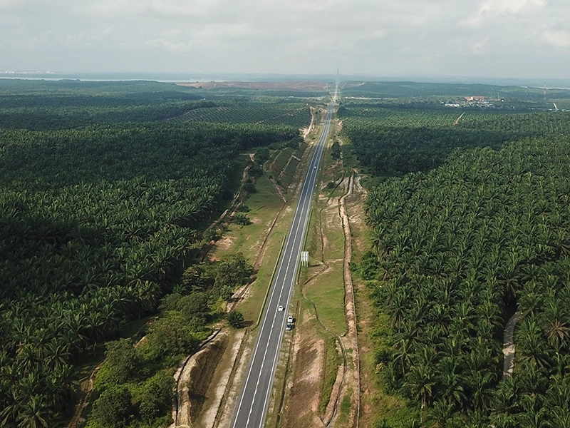
Highway Survey Project Results
260ha Area Mapped
70% Manpower Saved
80% Time Saved

Business Impact

  • 80% timeline reduction: 2 weeks vs 12 weeks traditional
  • RM 200k cost savings: Reduced manpower and equipment needs
  • 70% manpower saved Minimize risk of manual labor error & uncertainty
  • Superior accuracy: 1cm precision vs 5cm traditional methods

Kerian Canal Infrastructure Monitoring

Client IADA Kerian
Total Length 300 kilometers
Environmental Impact Zero ecosystem disruption
Total Savings RM 600,000

Large-Scale Infrastructure Mapping

Comprehensive mapping of 300-kilometer Kerian canal system for IADA Kerian. This extensive project demonstrates our capability to handle large-scale infrastructure monitoring and environmental assessment projects.

Environmental Excellence

Zero-impact monitoring methodology preserving sensitive ecosystem while delivering comprehensive environmental data. Advanced flight planning ensured wildlife protection and regulatory compliance.

Kerian Canal Infrastructure Monitoring
300km Project Scale
5 days Delivery
RM 600k Cost Savings

Strategic Outcomes

  • Large-scale project: 300km canal system mapping
  • RM 600k savings: Eliminated boat-based surveying costs
  • Environmental protection: Zero ecosystem disruption
  • Comprehensive data: Complete waterway analysis

Kota Belud River Sedimentation Study

Achievement Malaysia Book of Records
Survey Length 31 kilometers continuous
Delivery Speed Record 12-day turnaround
Analysis Depth Multi-temporal comparison

Record-Breaking Achievement

Malaysia Book of Records holder for longest continuous river survey at 31 kilometers for IADA Kota Belud. This unprecedented achievement demonstrates our capability to handle large-scale environmental monitoring projects.

Advanced Digital Twin Creation

Comprehensive digital twin documentation enabling advanced sedimentation analysis and environmental monitoring. High-density point cloud data provides unprecedented detail for engineering analysis with multi-temporal comparison capabilities.

River Study Point Cloud Analysis
50M+ Data Points
12 days Delivery
1cm Precision

Technical Innovation

  • 50M+ data points: Unprecedented detail level
  • 12-day delivery: Record turnaround time
  • Digital twin accuracy: Engineering-grade precision
  • Predictive capability: Future sedimentation modeling

Dam Infrastructure Inspection

Infrastructure Type Critical Water Infrastructure
Safety Protocol Zero-risk access method
Documentation Complete 3D structural model
Compliance Full regulatory standards

Critical Infrastructure Documentation

Comprehensive dam infrastructure inspection eliminating traditional safety risks. Complete 3D structural documentation enables predictive maintenance planning and structural integrity assessment.

Safety-First Methodology

Zero-risk inspection methodology eliminates personnel exposure to hazardous working conditions. Multi-sensor data collection provides comprehensive structural analysis without operational disruption.

Dam Infrastructure Inspection
100% Coverage
0 Safety Risks
3D Digital Twin

Regulatory Excellence

  • Zero safety incidents: Personnel risk elimination
  • Complete documentation: 100% structural coverage
  • Regulatory compliance: All safety standards met
  • Maintenance planning: Predictive analysis capability

Transformation Showcase

See the dramatic difference precision drone mapping delivers. Interactive before/after comparisons reveal the comprehensive detail and accuracy achieved across diverse project types.

Raw Site vs Processed Orthomosaic

Interactive slider comparison

🔄

IMAGE PLACEHOLDER

Before/After Slider Component

Left: Raw aerial photo
Right: Processed orthomosaic with measurements
Suggested: 1000x750px per image

Project: Highway Expansion Survey

Transformation: Raw imagery → GIS-ready orthomosaic

Construction Progress Monitoring

Month 1 vs Month 6 comparison

🔄

IMAGE PLACEHOLDER

Before/After Slider Component

Left: Construction site month 1
Right: Same site month 6
Suggested: 1000x750px per image

Project: Development Site Monitoring

Transformation: Track earthwork and construction progress

Standard vs Survey-Grade Accuracy

Precision comparison visualization

🔄

IMAGE PLACEHOLDER

Before/After Slider Component

Left: Standard GPS accuracy (2-5m error)
Right: RTK/PPK survey-grade (1cm accuracy)
Suggested: 1000x750px per image

Project: Infrastructure Inspection

Transformation: Consumer-grade → Survey-grade precision

💡 Implementation Note: Consider using an interactive before/after slider library like img-comparison-slider or before-after.js for smooth drag interaction. Alternative: Side-by-side static comparison with hover state transitions.

Transform Your Next Project Into a Success Story

Join Malaysia's leading enterprises who trust Dronify for strategic drone mapping solutions. Our senior specialists deliver measurable ROI, timeline acceleration, and competitive advantages across critical industries. Schedule your strategic consultation today.