Drone mapping done right
Malaysia's certified drone mapping specialist delivering survey-grade precision through advanced RTK/GPS technology and proven expertise across 12,400+ hectares.
CAAM RCoC-B
Malaysia Aviation
MBOR Certified
31km River Survey
CAA Norway
Drone Operator
FAA Part 107
US Certification
Core capabilities
Professional drone mapping services delivering measurable business value through precision technology, proven expertise, and comprehensive deliverables.
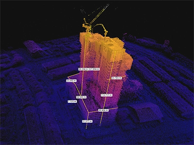
Survey-grade mapping
RTK/GPS-enabled precision mapping delivers ±2cm accuracy with Ground Control Point integration. Professional orthomosaics, 3D point clouds, and CAD-ready deliverables.
- Orthomosaic generation (1–5cm/pixel)
- Full-color 3D point clouds
- Digital surface/terrain models
- Volumetric analysis reports

Infrastructure inspection COMING SOON
Professional visual, thermal, and sensor-based inspections for infrastructure and asset management. This service is being prepared for launch.
- Structural assessment & analysis
- Thermal mapping & detection
- 3D textured mesh models
- Technical support documentation
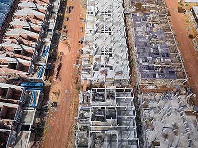
Progress monitoring
Time-stamped aerial data for project management and stakeholder reporting. Track changes, measure progress, and optimize construction workflows with precision data.
- Time-lapse documentation
- Stockpile volume monitoring
- Change detection analysis
- Progress measurement reports
Record achievement
Malaysia Book of Records: 31km continuous river survey completed in 6 days
Enterprise trust
Trusted by Gamuda Group, Ranhill Group, MADA, and government agencies
Proven results
Up to 70% cost savings and 85% time reduction vs. traditional ground surveying methods (case-specific results)
Service packages
Comprehensive drone mapping solutions tailored to your project requirements and budget. All packages include professional deliverables and technical support.
Basic
Initial site overviews · Progress monitoring
Cost price for first-time clients
- High-resolution orthomosaic (GeoTiff format)
- Digital surface model (DSM)
- Basic 3D point cloud (RGB colors)
- Site overview report
- Google Earth export (.kml format)
- Standard accuracy: 3–5cm/pixel GSD
- Coverage: Up to 50 acres
- Delivery: 3–5 business days
Best for
Small construction projects, initial site assessments, progress documentation, marketing materials
Advanced
Engineering · Construction planning · Detailed surveys
50-acre project example
- Survey-grade orthomosaic (1–2cm/pixel)
- Full-color 3D point cloud (.las/.laz formats)
- Digital terrain model (DTM/DEM)
- Contour maps (customizable intervals)
- 3D textured mesh model (.ply/.fbx formats)
- Volumetric analysis with calculations
- CAD/GIS integration ready formats
- Ground control points (±2cm accuracy)
- Professional quality report
Best for
Engineering consultants, construction planning, infrastructure development, land surveying
Enterprise
Large-scale infrastructure · Ongoing monitoring
Tailored to your requirements
- Everything in Advanced package
- Advanced classification (automated ML)
- Index maps & analysis (vegetation/moisture)
- Reflectance mapping (specialized analysis)
- Custom deliverables (client specifications)
- Ongoing monitoring (time-series analysis)
- Dedicated project manager
- Priority technical support
Best for
Government agencies, major infrastructure projects, mining operations, environmental monitoring
Dronify quality guarantee
100% safety record
Zero incidents across 500+ successful flights
Survey-grade accuracy
±2cm precision with GCP integration
Professional deliverables
Industry-standard formats for CAD/GIS
Ready for your next step?
Get expert consultation and detailed assessment for your drone services project.
Project assessment
Get expert consultation and detailed assessment for your drone services project requirements.
Start assessmentView portfolio
Explore our comprehensive portfolio of successful drone mapping, inspection, and monitoring projects.
View portfolioCalculate savings
Interactive ROI calculator to estimate potential cost savings and efficiency gains for your project.
Calculate savings