How do you assess widespread river system changes after a major earthquake when traditional surveys would take weeks and cost tens of thousands of dollars?
The 2015 earthquake that struck Mount Kinabalu triggered massive landslides, depositing enormous volumes of rock, sand, and gravel into Sabah's river networks. For the agricultural communities of Kota Belud, this wasn't just an environmental concern — it was a direct threat to irrigation systems that support extensive farmland downstream.
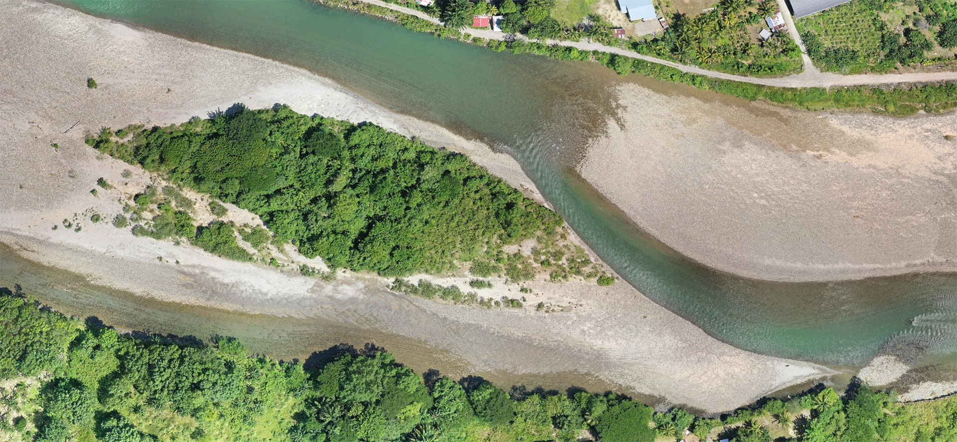
When engineering consultants needed to understand these complex changes quickly and cost-effectively, aerial drone mapping proved to be the game-changing solution that delivered comprehensive river assessment at 90% cost savings compared to traditional helicopter surveys.
The Challenge: Post-Earthquake River System Chaos
Widespread Sedimentation Impact
The Kota Belud area faced significant river system changes after the 2015 earthquake. Three major waterways — Sungai Kedamaian, Sungai Kawang-Kawang, and Sungai Jawi-Jawi — experienced dramatic morphological changes that posed serious challenges:
- Altered river channels with new sediment bars and braided flows
- Buried irrigation infrastructure affecting water intake systems
- Unpredictable water distribution to agricultural areas downstream
- Safety risks from unstable riverbanks and ongoing erosion
Traditional Assessment Limitations
Conventional ground-based surveys in this post-earthquake environment presented multiple challenges:
- Safety concerns from unstable terrain and ongoing landslide risk
- Accessibility issues in remote, mountainous locations
- Time constraints with seasonal weather limiting survey windows
- Cost prohibitions of helicopter-based aerial surveys
- Limited coverage of traditional measurement techniques
Engineering consultants needed a comprehensive, rapid, and cost-effective method to assess the full extent of sedimentation impacts across hundreds of kilometers of river systems.
The Strategic Drone Mapping Solution
Comprehensive Multi-Temporal Survey Program
Between November 2021 and August 2022, a systematic drone mapping program was implemented along 300-meter corridors for each affected river system. The survey strategy included:
Survey Objectives:
- Identify sand and rock sedimentation sites, particularly around river bends
- Detect changes in river direction and morphology over time
- Map irrigation-related infrastructure including water intake points and channels
- Assess downstream agricultural impacts from altered water flow
Technical Implementation:
- High-resolution aerial imagery with centimeter-level ground resolution
- Multi-temporal surveys to track changes over seasonal cycles
- Comprehensive corridor mapping covering river channels and floodplains
- 3D photogrammetric processing for volumetric analysis
Advanced Data Products and Analysis
Using professional drone photogrammetry software, captured imagery was processed to generate comprehensive mapping products:
Orthomosaics: Complete visual coverage with geographic accuracy for infrastructure mapping and sediment pattern analysis
Digital Surface Models (DSMs): Detailed elevation data showing sediment accumulation heights and volume calculations
3D Models: Interactive visualization tools enabling stakeholder understanding and decision-making support
Critical Insights and Measurable Outcomes
1. Precise Sediment Accumulation Mapping
Drone mapping revealed exact locations where sedimentation occurred, particularly at river bends and shallow stretches. High-resolution orthomosaics clearly identified light-colored sandy deposits and boulder clusters that could obstruct flow and cause localized flooding.
Quantifiable Results:
- Volumetric measurements of accumulated material using DSM analysis
- Priority area identification for dredging and stabilization efforts
- Risk assessment data for flood prediction and mitigation planning
2. River Channel Migration Analysis
Multi-temporal comparison revealed riverbank erosion and channel shifts, with some sections developing braided channel systems. These changes directly influence:
- Water flow velocity and sediment transport capacity
- Distribution patterns of irrigation water to farmland
- Infrastructure vulnerability to ongoing erosion processes
3. Irrigation Infrastructure Impact Assessment
Comprehensive mapping captured all irrigation-related features:
- Intake gates and diversion channels - condition and accessibility assessment
- Drainage outlets and distribution systems - operational status evaluation
- Buried or damaged infrastructure - maintenance and redesign requirements
Maintenance Planning Benefits:
- Asset condition inventory with GPS-accurate locations
- Priority ranking system for repair and replacement activities
- Design optimization data for climate-resilient infrastructure
4. Sustainable Resource Harvesting Evaluation
The surveys documented sand and rock harvesting operations around large sediment bars, enabling dual-impact assessment:
Positive Impacts:
- Channel depth maintenance through strategic sediment removal
- Blockage prevention supporting consistent irrigation flow
- Economic benefits for local communities through material sales
Risk Management:
- Riverbank stability monitoring to prevent over-extraction
- Flow pattern analysis to avoid unintended downstream consequences
- Sustainable extraction guidelines based on geomorphological data
Transformational Cost and Efficiency Benefits
Financial Performance Comparison
Traditional Helicopter Survey Costs:
- Daily rate: RM25,000-40,000 per helicopter day
- Multi-day requirement: 3-5 days for comprehensive coverage
- Total cost: RM75,000-200,000 for complete assessment
Drone Mapping Investment:
- Daily survey capacity: Multiple river sections per day
- Equipment and operator costs: Less than 10% of helicopter equivalent
- Total project cost: RM8,000-15,000 for equivalent coverage
Net Cost Savings: 85-90% reduction compared to traditional aerial methods
Operational Efficiency Gains
Time Performance:
- Data collection: Single operator mapping several kilometers daily
- Traditional alternative: 5-10 crew members over 2-3 weeks
- Time reduction: Over 90% faster data acquisition
Risk and Safety Benefits:
- Personnel safety: Eliminated need for crews in hazardous terrain
- Insurance costs: Reduced risk exposure for survey operations
- Weather flexibility: Rapid deployment during suitable conditions
Long-Term Strategic Value
Continuous Monitoring Capabilities
The drone mapping approach established ongoing monitoring capabilities that extend far beyond the initial post-earthquake assessment:
Dynamic System Tracking:
- Seasonal change documentation showing sedimentation patterns
- Infrastructure condition monitoring supporting preventive maintenance
- Environmental compliance reporting for regulatory requirements
Integrated Water Resource Management
Evidence-Based Decision Making:
- Quantified sediment volumes supporting dredging budget allocation
- Infrastructure prioritization based on condition and vulnerability data
- Sustainable harvesting policies informed by geomorphological analysis
Stakeholder Communication:
- Visual documentation for community engagement and education
- Technical reports with professional mapping products for engineering analysis
- Regulatory submissions meeting government agency requirements
Implementation Framework and Lessons Learned
Critical Success Factors
-
Multi-Temporal Approach: Post-earthquake river systems remain unstable for years, requiring continuous monitoring to track changes and adjust mitigation strategies
-
Integrated Management Strategy: Effective sedimentation control must balance engineering solutions with regulated resource harvesting to prevent downstream irrigation failures
-
Technology Integration: Drone mapping provides long-term value as an ongoing tool for flood management, irrigation planning, and environmental conservation
Scalability and Replication
The Kota Belud river sedimentation study demonstrates transferable methodologies applicable to similar challenges throughout Malaysia and Southeast Asia:
- Post-disaster assessment protocols for rapid infrastructure evaluation
- Agricultural water security monitoring supporting food production stability
- Sustainable resource management balancing economic and environmental needs
- Community resilience building through improved disaster preparedness
Measurable Impact on Agricultural Communities
Water Security Assurance
Irrigation System Reliability:
- Consistent water distribution through optimized infrastructure placement
- Reduced flood risk from strategic sediment management
- Enhanced drought resilience via improved water retention capacity
Agricultural Productivity Benefits:
- Stable crop yields through reliable irrigation scheduling
- Reduced crop loss from flooding and water shortages
- Economic stability for farming communities dependent on consistent water supply
Community Empowerment
Local Knowledge Integration:
- Traditional ecological knowledge combined with technical mapping data
- Community-based monitoring capabilities for ongoing system management
- Sustainable livelihood opportunities through regulated sand harvesting
Transforming Disaster Response with Drone Technology
The post-earthquake river sedimentation study in Kota Belud demonstrates the transformative potential of aerial drone mapping in disaster response and water resource management. By delivering high-resolution, timely, and actionable data at unprecedented cost-effectiveness, drone technology enabled comprehensive assessment and management of complex river dynamics.
Contact Dronify today to learn how professional drone mapping can support your disaster response, infrastructure assessment, and water resource management needs. Our proven expertise in challenging terrain and post-disaster environments ensures reliable data collection and analysis when rapid, accurate information is critical for community safety and economic stability.
Whether you're managing post-disaster recovery, monitoring environmental changes, or supporting agricultural water security, our comprehensive drone mapping services provide the foundation for evidence-based decision-making and sustainable resource management.