River sedimentation study
Post-earthquake digital twin mapping for environmental research — Kota Belud, Sabah
The challenge
Following seismic activity in Sabah, IADA Kota Belud required a comprehensive sedimentation study of the Tempasuk River system near Kota Belud. Understanding post-earthquake changes in river morphology, sedimentation patterns, and channel dynamics was critical for assessing flood risk, planning river management interventions, and protecting downstream agricultural communities.
Traditional river surveying methods using boats and manual measurement would have been dangerous in the altered post-earthquake terrain, prohibitively slow for the 31km study area, and unable to produce the digital twin models needed for advanced hydrological analysis.
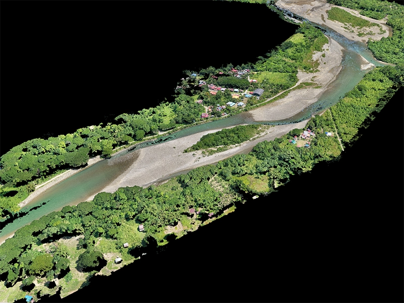
The solution
Dronify executed a 31km continuous aerial river survey — the longest continuous aerial river survey in Malaysia, certified by the Malaysia Book of Records. Using survey-grade RTK positioning and overlapping flight paths, the team captured comprehensive high-resolution imagery of the entire river corridor in 6 days of fieldwork.
Advanced photogrammetric processing generated a complete digital twin of the river system: high-resolution orthomosaics for visual analysis, 3D point clouds for volumetric assessment, digital elevation models for flood modelling, and change detection datasets for comparing pre- and post-earthquake conditions.
Results & impact
- Malaysia Book of Records certified: Longest continuous aerial river survey at 31km
- Complete digital twin: High-resolution 3D model of entire river system for ongoing analysis
- 1cm precision: Survey-grade accuracy enabling engineering-level flood risk modelling
- 6-day fieldwork: Rapid deployment in challenging post-earthquake terrain
- Multi-format deliverables: Orthomosaics, point clouds, DEMs, contour maps, and GIS overlays
- Research foundation: Data supporting ongoing environmental monitoring and flood prevention planning
Have a similar project?
Get a free project assessment for your river survey, environmental study, or sedimentation analysis needs.